
El Niño Is Back, And 2026‘s Could Be the Strongest in Modern History
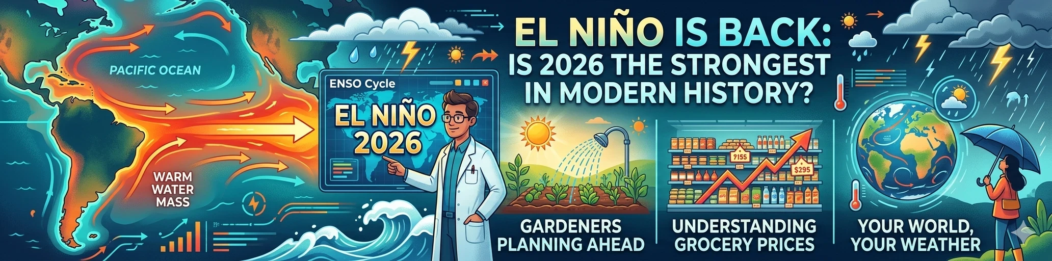
If you’ve noticed the weather feeling a little off lately, hotter summers, weird rainfall patterns, an eerily quiet Atlantic hurricane season, there’s a good chance El Niño has something to do with it. The phenomenon is back in 2026, and climate scientists are sounding the alarm: this one could be record-breaking.
Whether you’re a weather nerd, a gardener trying to plan ahead, or just someone wondering why your grocery prices keep climbing, understanding El Niño is increasingly useful knowledge. Here’s everything you need to know, from what it actually is to what it means for your corner of the world over the next year.
What Is El Niño?
El Niño is the warm phase of a larger climate cycle called ENSO, the El Niño-Southern Oscillation. It’s a naturally occurring phenomenon involving the interaction between the ocean surface and the atmosphere across the tropical Pacific Ocean, and it’s one of the most powerful drivers of global weather variability on Earth.
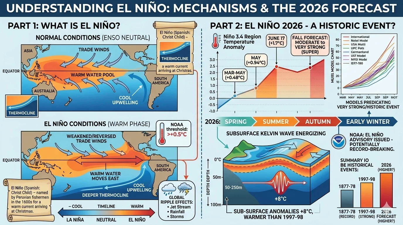
Under normal conditions, strong trade winds blow from east to west along the equator, pushing warm surface water toward Asia and Australia, and allowing cooler water to well up along the coasts of South America. El Niño disrupts this pattern. The trade winds weaken, sometimes reversing entirely, and that warm water sloshes back eastward, raising sea surface temperatures across the central and eastern tropical Pacific.
NOAA officially declares an El Niño when temperatures in the equatorial Pacific stay at least 0.5°C above average for several consecutive months. That threshold sounds modest, but the atmospheric ripple effects are enormous. Because the ocean holds and releases so much heat, even a small sustained temperature shift reshuffles rainfall patterns, jet streams, storm tracks, and seasonal temperatures across the entire planet.
The name “El Niño,” Spanish for “little boy,” or more specifically “the Christ Child,” was originally used by Peruvian fishermen in the 1600s to describe a warm ocean current that arrived around Christmastime and drove fish away from their usual feeding grounds. Modern scientists use it to describe the large-scale climate pattern we now understand as ENSO’s warm phase.
What’s Happening in 2026
The short version: El Niño has officially arrived, it’s strengthening fast, and forecasters are using words like “very strong,” “super,” and “potentially record-breaking.”
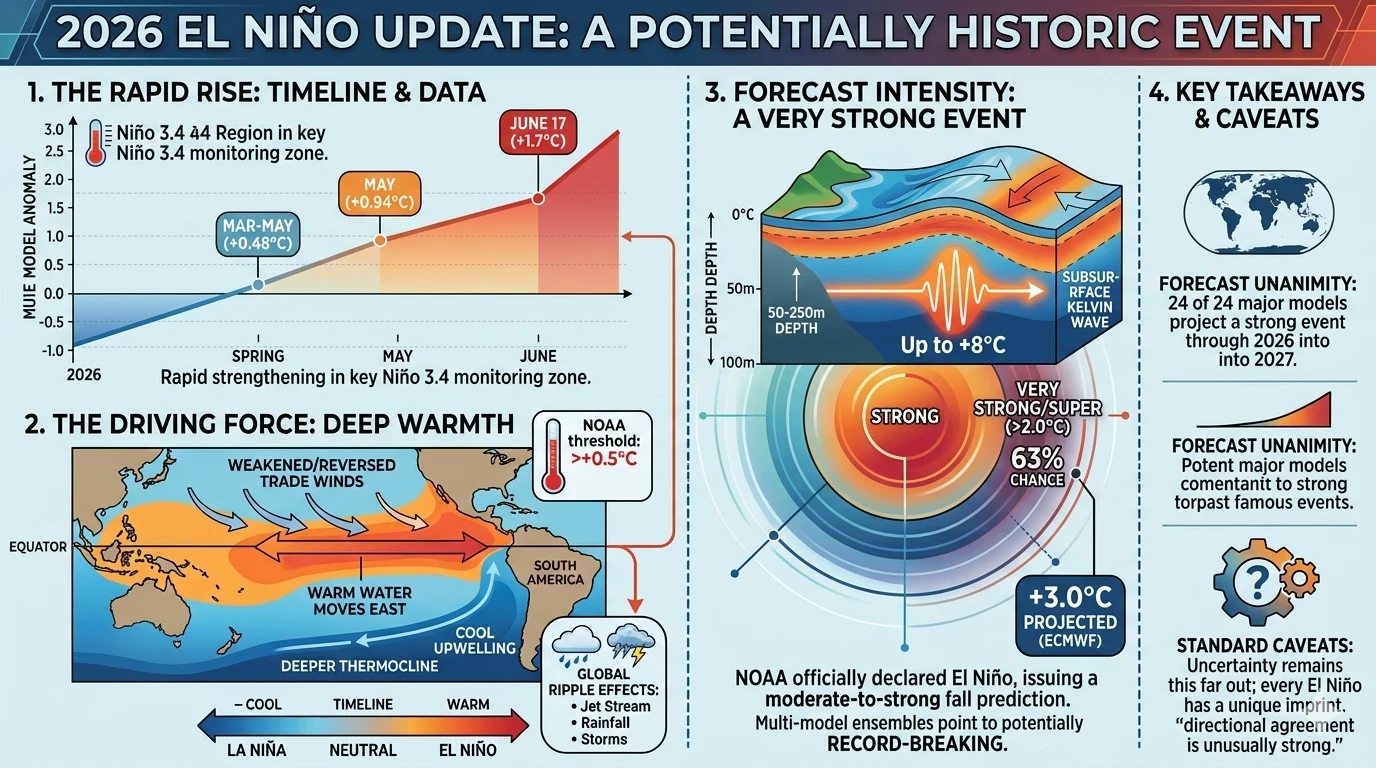
Here’s the timeline of how we got here. After a period of La Niña conditions (El Niño’s opposite, the cool phase) and a stretch of neutral conditions earlier this year, ocean temperatures in the tropical Pacific began rising rapidly in spring 2026. The observed sea surface temperature anomaly in the Niño 3.4 region, the key monitoring zone in the central Pacific, climbed from +0.48°C during March through May, to +0.94°C in May, and then surged further to +1.7°C by the week centered on June 17, 2026.
NOAA’s National Weather Service officially announced that El Niño has developed in the tropical Pacific and issued an El Niño Advisory, with predictions that it will intensify to a moderate or strong level this fall.
But many forecasters believe “moderate or strong” may be underselling it. As models have become more aggressive, multi-model ensemble predictions are now explicitly pointing toward a very strong, and quite possibly record-breaking, El Niño by autumn or early winter 2026. The median forecast from every major international model ensemble depicts at least a strong event, with the majority indicating a top-tier, very strong to historic event.
Several forecasts suggest this event could become the strongest El Niño in modern history, potentially surpassing the record-breaking event of 1877–1878. That’s a striking claim, and while forecasting certainty increases as the event matures, the current trajectory is alarming even by historical standards.
What’s driving the intensity? A massive subsurface oceanic Kelvin wave, a pulse of warm water traveling eastward beneath the surface, has been growing more energetic in recent weeks, with subsurface anomalies reaching as high as +8°C at depths of 50–250 meters, running warmer than the 1997–98 event at the same stage. When this wave rises to the surface, it acts as a release valve for accumulated heat, dramatically amplifying surface warming.
https://www.tiktok.com/@dudebuddy21/video/7532703309640076599
How Strong Could It Get?
To understand the scale, it helps to know how El Niño events are classified. A “super” or “very strong” El Niño is one where sea surface temperatures in the monitored Pacific region exceed +2.0 °C above the long-term average. The three most recent super events occurred in 2015–16, 1997–98, and 1982–83, each one causing significant global disruption.
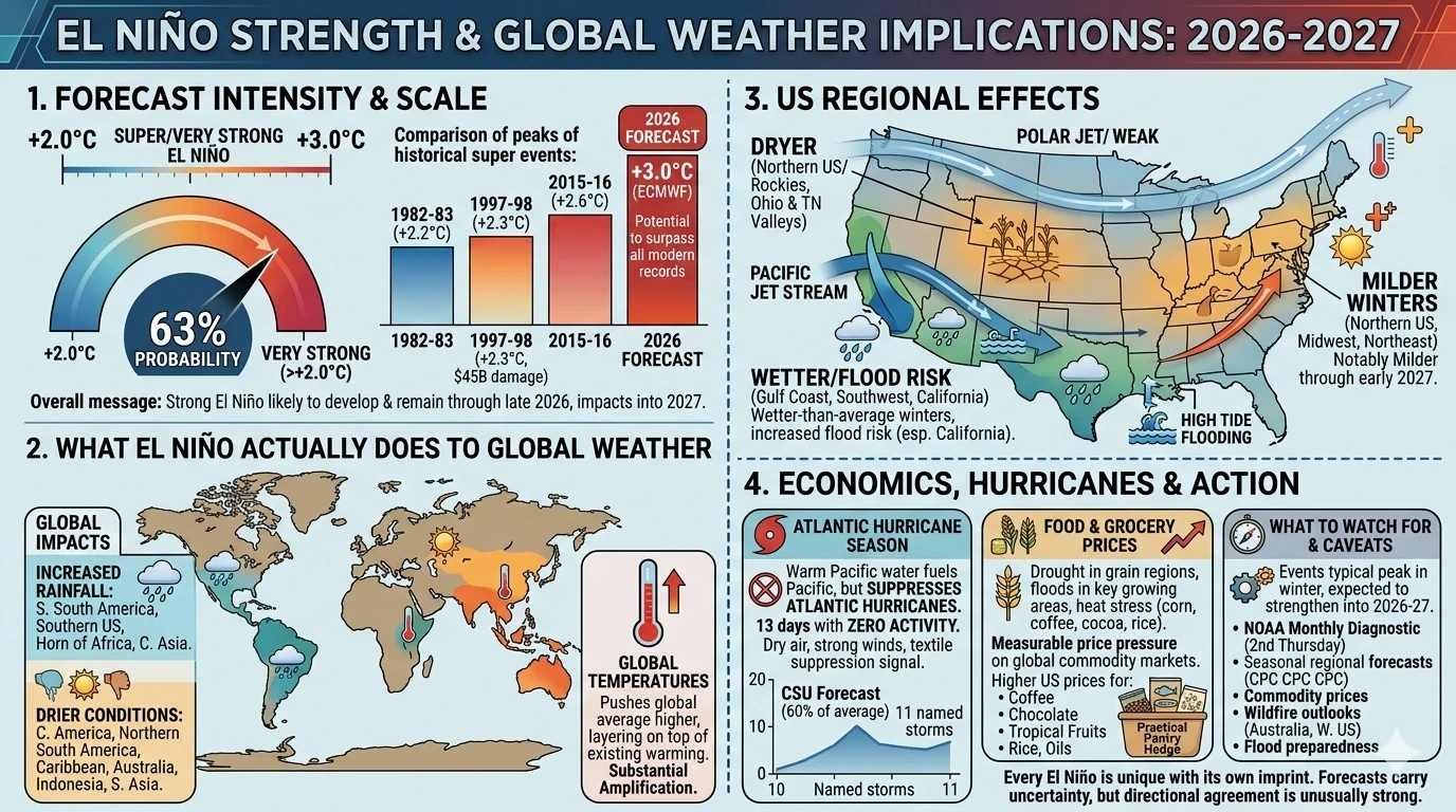
Forecasters predict a 63% chance of sea surface temperatures exceeding 2.0 °C in the Niño-monitored region of the Pacific, which would meet NOAA’s threshold for a “very strong” El Niño.
The overall message is consistent across the 24 participating forecast models: a strong El Niño event is likely to develop and remain in place through late 2026, with potentially severe climate impacts extending into 2027.
Some forecasts are even more dramatic. The ECMWF, the European Centre for Medium Range Weather Forecasts, widely considered the gold standard of global modeling, has projected sea surface temperatures reaching +3°C above average by December. For context, the infamous 1997–98 El Niño, which caused an estimated $45 billion in damages globally and contributed to flooding, drought, and wildfire on multiple continents, peaked around +2.3°C.
It’s worth noting the standard caveats here. As NOAA’s National Weather Service director Ken Graham put it: “Every El Niño is not the same; each one is unique with its own imprint on our weather.” Forecasts carry uncertainty, especially this far out. But the directional agreement across models from Europe, the United States, and Australia is unusually strong, and unusually alarming.
What El Niño Actually Does to Weather
When El Niño strengthens in the tropical Pacific, it reorganizes atmospheric circulation patterns around the globe. The effects don’t show up the same way everywhere, some regions get wetter, some get drier, some see warmer winters, some face drought. Here’s a breakdown of the key impacts:
In the United States
During a typical El Niño winter, the jet stream over the north Pacific Ocean tends to shift southward, bringing the storm track over the southern tier of the United States. The southward shift in the storm track also leads to drier conditions over the Northern Rockies and the Ohio and Tennessee valleys. For temperatures, El Niño often leads to warmer-than-usual winters over the northern United States.
That’s significant news for Midwest and Northeast residents who might normally brace for brutal winters, a strong El Niño could mean notably milder temperatures through early 2027. Meanwhile, the Gulf Coast, Southwest, and California can expect wetter-than-average winters, with increased flood risk.
High tide flooding could become a higher risk in parts of the United States, especially on the West Coast. For California in particular, which has experienced both devastating droughts and catastrophic atmospheric river flooding in recent years, a strong El Niño winter raises the flood risk considerably.
Atlantic Hurricane Season
Here’s some genuinely good news buried in the bigger story: during the boreal summer, El Niño’s warm water can fuel hurricanes in the central and eastern Pacific Ocean, while it hinders hurricane formation in the Atlantic Basin.
That suppression effect is already showing up. The 2026 Atlantic hurricane season was 13 days old with zero tropical activity, dry air and strong upper-level winds across the entire basin, a textbook El Niño suppression signature. Colorado State University responded by lowering its forecast to just 11 named storms, predicting activity about 60% of the 1991–2020 average.
For anyone living along the Gulf Coast or Atlantic seaboard, this is meaningful. A suppressed Atlantic hurricane season reduces the risk of major landfalling storms, one of El Niño’s clearest and most consistent benefits for the United States.
Global Impacts
El Niño is typically associated with increased rainfall in parts of southern South America, the southern United States, parts of the Horn of Africa, and central Asia, and drier conditions over Central America, northern South America, the Caribbean, Australia, Indonesia, and parts of southern Asia.
The drying effect over Australia, Indonesia, and the broader western Pacific is one of El Niño’s most consistent and destructive signatures. These regions depend on their wet seasons for agriculture and water supply. A strong El Niño can decimate crop yields, strain water reservoirs, and dramatically increase wildfire risk. The 1997–98 event triggered devastating fires across Indonesia, with smoke blanketing Southeast Asia for months.
For the June–July–August season, forecasts project a nearly universal dominance of above-normal temperatures in nearly all parts of the globe, increasing risks of heat stress and compounding hazards in some regions, and accelerating the development of drought conditions where rainfall is reduced.
Global Temperatures
El Niño doesn’t just affect rainfall and storms, it also pushes global average temperatures higher, layering on top of the warming already driven by greenhouse gas accumulation. The record-breaking global temperatures of 2015–16 were substantially amplified by the strong El Niño of that period. If this event approaches or exceeds that intensity, 2026 and 2027 could set new global temperature records.
What This Means for Food and Grocery Prices
Here’s where El Niño hits close to home for anyone watching their food budget. The same disruptions to rainfall and temperature patterns that affect ecosystems also affect agricultural production. Drought in major grain-producing regions drives up cereal prices globally. Floods in key growing areas can destroy harvests. Heat stress reduces yields from coffee, cocoa, corn, and dozens of other crops.
The 1997–98 El Niño contributed to significant food price spikes in affected regions. A stronger 2026 event, particularly one that delivers drought to Australia, Indonesia, Southeast Asia, and parts of Central America, could translate to measurable price pressure on global commodity markets.
For budget-conscious shoppers in the United States, this could mean higher prices on products like coffee, chocolate, tropical fruits, rice, and certain cooking oils over the next 12–18 months. Wetter-than-average winter conditions in California and the Southwest could alternatively benefit some domestic produce yields, but flooding risk cuts both ways.
This is a good time to diversify your pantry toward shelf-stable staples that aren’t heavily dependent on single-source growing regions: dried legumes, oats, canned fish, whole grains, and domestic produce. Buying ahead on non-perishables when prices are currently stable is a simple, practical hedge.
What to Watch For the Rest of 2026
El Niño events typically peak in the Northern Hemisphere winter, and El Niño conditions are present and expected to strengthen into the Northern Hemisphere winter 2026–27. That means the most intense effects, both globally and across the United States, are still ahead.
Key things to monitor over the coming months:
- NOAA’s monthly ENSO Diagnostic Discussions, which update El Niño status and forecasts every second Thursday of the month.
- Seasonal forecasts for your region from NOAA’s Climate Prediction Center (CPC), which translate ENSO signals into precipitation and temperature outlooks for specific parts of the country.
- Agricultural commodity prices, particularly for coffee, rice, palm oil, and cocoa, products heavily affected by El Niño’s rainfall disruptions across the tropics.
- Wildfire outlooks for Australia and the western United States, where El Niño can dramatically expand fire conditions.
- Flood preparedness for anyone in Southern California, the Gulf Coast, or the Ohio River Valley, historically wetter zones during strong El Niño winters.
El Niño probabilities remain exceptionally high at 99% through the October–December to December–February period, followed by 98% and 97% for early 2027. In other words, this isn’t going away anytime soon. The effects will extend well into next year.
The Bottom Line
El Niño is a natural part of Earth’s climate system, it has been occurring for millennia. But the 2026 event is shaping up to be anything but ordinary. With sea surface temperatures already surging past recent baselines and an ominous subsurface heat pulse still propagating eastward, the scientific consensus is pointing toward a historic event that could rival or exceed the most powerful El Niños in the modern record.
That means disrupted weather patterns, heightened global temperatures, flood risk in some regions and drought in others, a suppressed Atlantic hurricane season, and potential pressure on global food supplies, all simultaneously.
The best posture for individuals is awareness and modest preparation: stay informed through NOAA’s official updates, understand your region’s typical El Niño impacts, shore up your pantry with cost-effective shelf-stable foods, and keep an eye on how this increasingly energetic event continues to evolve through the rest of the year.
This one is worth paying attention to.